Issues - Water (Hydrogeology)
This is a major concern.
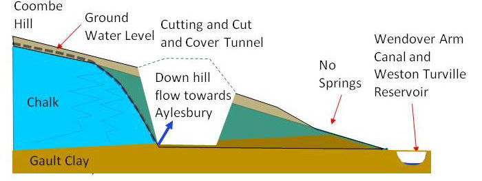
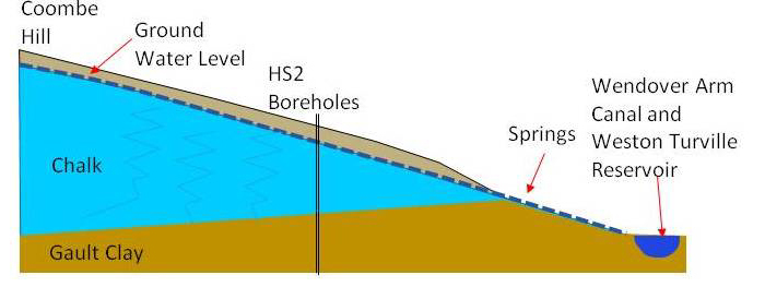
Coombe Hill and the surrounding elevated land acts as a large 'sponge' (known as an aquifer) soaking up rain water. This sponge then 'leaks' out the water and it currently feeds springs that in turn supply the Wendover Arm canal and the Weston Turville Reservoir nature reserve.
HS2's plan in the area is to cut through the Coombe Hill Aquifer. At the time we petitioned in the House of Commons back in 2015, hydrogeological investigations undertaken for the Wendover Parish council showed that the 80m wide, 20m deep cut that will be made to build the green tunnel and North Cutting would irreparably damage the aquifer.
The result is that the springs that feed the Weston Turville Reservoir SSSI and the Wendover Arm canal are likely to be starved of water which will be diverted down Stoke Brook towards Stoke Mandeville and Aylesbury. This in turn is likely to resulting in increased risks of flooding and the reservoir will be irreparably damaged.
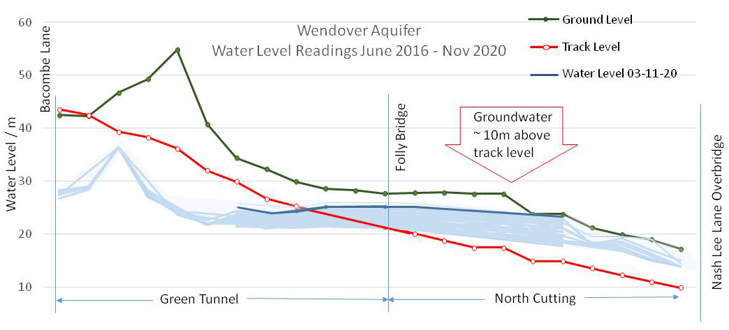
Measurements show the track level will be up to 10m below the ground water level, so the excavation will inevitably flood unless it is lined. This is why we have seen many test rigs at Wellwick Farm. Wendover have been actively campaigning for mitigation to be built into the design and HS2 have belatedly realised there is a problem and acknowledge they needed to change the design agreed in Parliament!
Based on the current design in the HS2 Act, the contractors would need to line the slopes of the cutting which will be expensive. The best technical solution has always been constructing a tunnel so as not to disturb the ground through which the ground water flows. Since this has been refused, Wendover HS2 suggested a retained cutting (a cutting with vertical or near-vertical sides) which will greatly reduce the amount of tanking needed, and also provide some additional noise mitigation.
Part of the assurances of the HS2 act require that the impact on groundwater is minimised and there should be no increase in flood risk. One of the main parties who can influence the delivery of these assurances are Buckinghamshire Council to whom HS2/EKFB have to make what is known as a schedule 17 design submission. This was submitted in August 2022. However, the council were limited in the scope of what they could demand, and were not able to respond as robustly as we would have liked.

Our concern is that if the Environment Agency and Natural England do not respond to the design submission robustly, then we will lose the opportunity to protect Weston Turville Reservoir SSSI and the canal for ever. Worse, we will see increased water flows down Stoke Brook leaving the new housing in Aylesbury to face more flooding.
A presentation given to the councillors is available here.
In addition to the Council’s interests in what the eventual design will look like (along with their role as the Local Flood Authority) the Environment Agency have the power of approval of the actual construction works with respect to impact on watercourses.
Discussions between the EA and HS2 have been continuing, and (as of July 2023) permission to start excavation had not been granted.
The design submitted to the Council includes the use of "low permeability walls" to provide tanking on each side of the North Cutting where groundwater flows would otherwise escape into the track drainage system. To the west of the line this will have the effect of raising the groundwater level, which will then discharge into a flight of balancing ponds before emptying into Stoke Brook. Consequently the amount of groundwater flowing to the east of the line will be reduced, including the volume of water made available to the Weston Turville Reservoir SSSI from Stoke Brook. HS2 will need to convince the EA that their "Water Framework Directive Section 19" requirements regarding interference with groundwater are met, which covers both the volume and quality of water passed on to downstream watercourses.
The critical part of this is that the scheme includes an active water quality and quantity monitoring programme during construction and at least six years of railway operation. The scope of the management plan needs to include the Weston Turville SSSI (which we have been campaigning about for many years). We will also be pressing for monthly results to be made publicly available in line with Affinity’s precedent for the rest of the Chilterns section of the railway.
The downstream flood risk is dominated by the anticipated surface water runoff, including the impact of a "1 in 100 years" storm event and climate change. Surface water north of the Small Dean Viaduct is expected to be captured in ponds near Bacombe Lane and carried in a storm culvert alongside the green tunnel to the balancing ponds at the North Cutting. We are concerned that this diversion of surface water will cause further reduction in the groundwater flows available to Hampden Pond, which were reduced by the impact of the A413 bypass excavation. HS2’s design team have suggested that an artesian well may be an effective means of maintaining the water levels in the pond, and we are investigating this solution.
The design of the line has been considered in isolated sections, and we were concerned that the design of the drainage systems in the Stoke Mandeville area was approved as being adequate in March 2022 before the impact of the flows from the upstream Small Dean, Green Tunnel and Nash Lee areas was understood. We understand that a more "joined-up" appreciation of the complete area has now been considered, resulting in a resubmission of the Stoke Mandeville design in June 2023 with additional pond capacity.
We are continuing to engage with both the Environment Agency and the HS2 contractors to ensure that our watercourses are protected by the eventual design; that monitoring arrangements are in place to track the impact of the line once constructed; and that facilities are available to improve the overall system if needed.